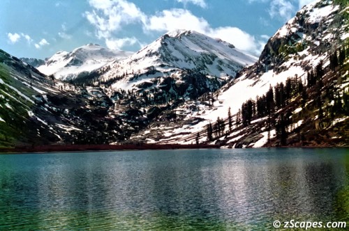
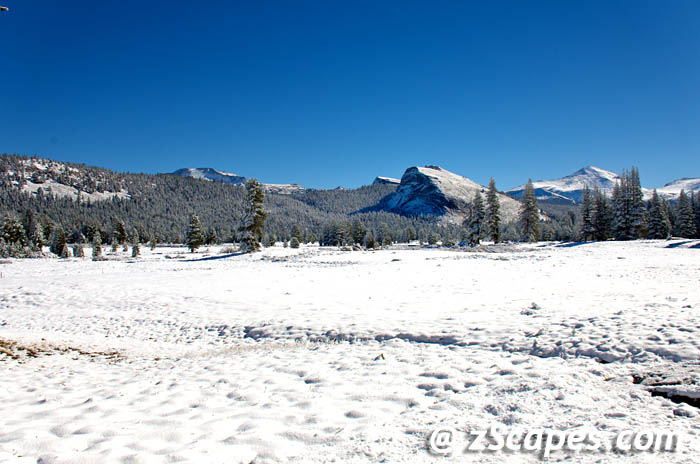
Teddy Rossevelt

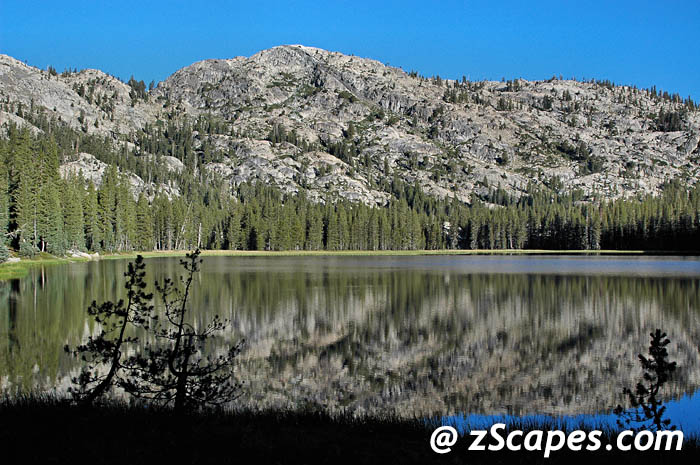
Bear Lake
Location
Yosemite Park & Wilderness
Elevation & GPS
8892'
38.09693°N-119.69653
38.09693°N-119.69653
Visits & Activity
2002 Gn, Mz, Gs viewed
Interesting Facts & Highlights
Easy Southwest climb from Peninsula Lake above Huckleberry. Was stocked at one time with Rainbows, but given the small amount of traffic and the cutbacks in fish plantings, I would consider the chances low for dinner out of this lake.

Benson Lake
Location
Yosemite Park & Wilderness
Elevation & GPS
7581'
38.01636°N-119.5291°W
38.01636°N-119.5291°W
Visits & Activity
2006 Gn, Mz, Tl, Rl camp
Interesting Facts & Highlights
Large deep lake with a wide sandy shore. As you emerge from the tree cover there are several good campsites to both the left and right. Left side is a bit more secluded but the right side offers camps in between the sandy shore and rolling meadows. Named for 'Batty' Benson, army officer and acting superintendent who blazed many trails that bare a distinct H tree mark.

Cathedral Lake
Location
Yosemite Park & Wilderness
Elevation & GPS
9288'
37.84508°N-119.42412°W
37.84508°N-119.42412°W
Visits & Activity
2007 Gn, Mz first view from Catherdal Peak
Interesting Facts & Highlights
In 1863 the California Geological Survey identified Cathedral Peak, and by default, this name fell to many of the features that surrounded this area. Cathedral Lake was named by the time the first 'Mt Lyell 30' map was drawn in 1901. Fishing: Rainbows

Dorothy Lake
Location
Yosemite Park & Wilderness
Elevation & GPS
9393'
38.17694ºN-119.58829ºW
38.17694ºN-119.58829ºW
Visits & Activity
2006 Gn, Mz, Rl, Tl camp
2002 Gn, Mz camp
1999 Gn, Mz, Gs camp
1994 Gn, Mz, Gs camp
2002 Gn, Mz camp
1999 Gn, Mz, Gs camp
1994 Gn, Mz, Gs camp
Interesting Facts & Highlights
Wind swept with sweeping views and plenty of day hike opportunities. Good spot for a base camp, however it is on the Pacific Crest trail and gets a bit of traffic. Fishing: Rainbows up to 20 inches
Elizabeth Lake
Location
Yosemite Park & Wilderness
Elevation & GPS
9508'
37.845°N-119.370°W
37.845°N-119.370°W
Visits & Activity
2013 Mz first view
Interesting Facts & Highlights
Pretty straightforward on this one. R.B. Marshall named it for his niece in 1909, Elizabeth Crow Simmons. First appeared on the third edition of the Mt Lyell 30' map of 1910.

Evelyn Lake
Location
Yosemite Park & Wilderness
Elevation & GPS
10334'
37.8059°N-119.3258°W
37.8059°N-119.3258°W
Visits & Activity
2013 Mz first view
Interesting Facts & Highlights
Taken from Johnson Peak after a September snowfall. Named for one of the daughters of Major W. Forsyth, acting superintendent of Yosemite National Park from 1909-12. The Mt Lyell 30' 1910 map was first mention. A peak, ridge and four other lakes near Tower peak are associated with the Major and his daughters.

Fawn Lake
Location
Yosemite Park & Wilderness
Elevation & GPS
8127'
Location: 38.1135, -119.7072
Location: 38.1135, -119.7072
Visits & Activity
2014 Mz, Gn view and pass by
Interesting Facts & Highlights
A small shallow lake not listed in any of my reference materials. It feeds Kendrick Creek and is cross-country from Huckleberry to Peninsula Lake. We passed just south of it on our Yosemite Ridges 2002 trip. If you want isolation, this is the spot !!! Fishing: Unknown (most likely a winter freeze)

Inferno Lakes
Location
Yosemite Park & Wilderness
Elevation & GPS
7979 & 7936'
Location: 38.0894, -119.7579
Location: 38.0894, -119.7579
Visits & Activity
2014 Mz, Gn, Js first view x-Wheeler Peak
Interesting Facts & Highlights
Name origin is unknown. First appeared on the Pinecrest 15' quad in 1956. Most likely very light usage.

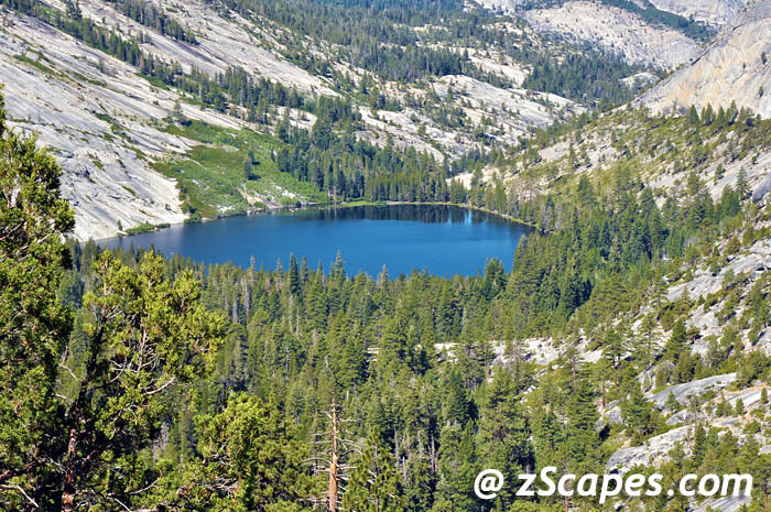
Lower Maclure Lake
Location
Yosemite Park & Wilderness
Elevation & GPS
10512'
37.76487°N-119.27585°W
37.76487°N-119.27585°W
Visits & Activity
2009 Mz first image
Interesting Facts & Highlights
The Maclure glacier drains primarily into Maclure Lake which in turns drains down in to this lake which is not named but I have designated as Lower. The Whitebark pines provide a bit of shelter, and if you crave isolation this is the spot. There is a bit of a climb up the facewall from the trail split at the footbridge along the John Muir/PCT trail, but the views are awesome and extends for 360 degrees. Fishing: Unlikely

Lukens Lake
Location
Yosemite Park & Wilderness
Elevation & GPS
8230'
37.860°N-119.616°W
37.860°N-119.616°W
Visits & Activity
2012 Mz, Bf first visit
Interesting Facts & Highlights
Known as the 'John Muir of Southern California', Theodore Parker Lukens, an advocate of conservation and reforestation, was acknowledged for his efforts. The lake was formed when the Hoffman Glacier was doing its lifelong work, eroding the ground beneath. The glacier ice flows overtopped the hills and gaps of the northwest divide, one of them being this pass and creating the lake.

Mary's Lake
Location
Yosemite Park & Wilderness
Elevation & GPS
9619'
38.14381ºN-119.5617ºW
38.14381ºN-119.5617ºW
Visits & Activity
2005 Gn, Mz camp
2000 Gn, Mz day hike
2000 Gn, Mz day hike
Interesting Facts & Highlights
Gateway to Tilden Lake, dramatic granite wall formations and views both up and down country. Staging point for climbing Tower and Watchtower peaks. Named by Robert Marshall for one of daughters of Col. Forsyth. Fishing: Goldens

May Lake
Location
Yosemite Park & Wilderness
Elevation & GPS
9329'
37.84801ºN-119.49316ºW
37.84801ºN-119.49316ºW
Visits & Activity
2013 Gn, Mz hike by
2010 Gn, Mz Hi-Sierra camp
2006 Bf, Mz Hi-Sierra camp
2010 Gn, Mz Hi-Sierra camp
2006 Bf, Mz Hi-Sierra camp
Interesting Facts & Highlights
Named after the wife of Charles Hoffman who was the first to climb Mt. Hoffman which rises above the back side of the lake. This geographic center of the park is also the location of one of the Yosemite High Sierra camps on it's shore. And as this is the drinking water source for the Yosemite valley, no swimming is allowed (at least that is what is posted).
Merced Lake
Location
Yosemite Park & Wilderness
Elevation & GPS
7212
37.73823ºN-119.41301ºW
37.73823ºN-119.41301ºW
Visits & Activity
2010 Gn, Mz Hi-Sierra camp
Interesting Facts & Highlights
John Muir mentioned the lake in 1872 while heading to glaciers at the head of the river, calling it Shadow Lake. The Merced name was first shown on the Mt Lyell 30' map in 1901, however, some maps of the era do not even show a lake!

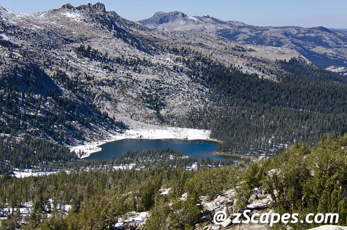
Mile 160 Lake
Location
Yosemite Park & Wilderness
Elevation & GPS
10194'
37.76693°N-119.25633°W
37.76693°N-119.25633°W
Visits & Activity
2009 Gn, Mz camp
Interesting Facts & Highlights
This is another unnamed lake along the PCT at the 160 mile marker of the John Muir trail. A gorgeous spot to spend a night or two with ample camp sites and never ending views. A good stage point for a Mt. Lyell attempt as the lakes further up the trail (and closer to the climb) do not compare with this gem. Wind can be a factor here, so pick your camp carefully and head for the shore to catch tonight's dinner. Fishing: Not known but activity observed

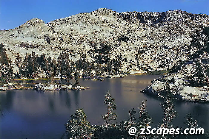
Miller Lake
Location
Yosemite Park & Wilderness
Elevation & GPS
9449'
37.99278ºN-119.41912ºW
37.99278ºN-119.41912ºW
Visits & Activity
2006 Gn, Mz, Tl, Rl camp
Interesting Facts & Highlights
Nestled nicely along the trail at a good breakpoint. Campsites available on the western shore and to the left of this picture above scattered tarns. A quick scramble up the western ridge gives way to views of the Grand Canyon of the Tuolumne River. Named in recognition of the person who recommended this site to Lt.McClure and his men. Historians seem to believe that this was not the lake but the name has stuck. Fishing: Unknown

Otter Lake
Location
Yosemite Park & Wilderness
Elevation & GPS
8911'
38.08882ºN-119.65723ºW
38.08882ºN-119.65723ºW
Visits & Activity
2002 Gn, Mz camp (Gs close by)
Interesting Facts & Highlights
Another get away spot. Lake drains East into Falls Creek and South into Frog Creek drainages. Several smaller lakes abound for great day hikes. Naming unknown, best guess is someone saw an otter at the lake. Fishing: Planted with Golden's. None evident in 2002
Peninsula Lake
Location
Yosemite Park & Wilderness
Elevation & GPS
8810'
38.10402ºN-119.69089ºW
38.10402ºN-119.69089ºW
Visits & Activity
2002 Gn, Mz Gs camped
Interesting Facts & Highlights
If you want quiet and out of the way, this is it. Haystack peaks looms overhead and turns colors to match the mood of day or night. Several moderate peak ascents nearby. Named for obvious geographical formations. Fishing: Planed w/Rainbows- Not evident in 2002

Upper Peninsula Lake
Location
Yosemite Park & Wilderness
Elevation & GPS
8892'
38.09693°N-119.69653
38.09693°N-119.69653
Visits & Activity
2002 Gn, Mz, Gs hike by
Interesting Facts & Highlights
Easy Southwest climb from Peninsula Lake above Huckleberry. Was stocked at one time with Rainbows, but given the small amount of traffic and the cutbacks in fish plantings, I would consider the chances low for dinner out of this lake. Fishing: Unknown

Smedberg Lake
Location
Yosemite Park & Wilderness
Elevation & GPS
9222'
38.01438ºN-119.48674ºW
38.01438ºN-119.48674ºW
Visits & Activity
2006 Gn, Mz, Tl, Rl camped
Interesting Facts & Highlights
Windswept medium lake with a meadow inlet that offers some shelter and campsites. Best we found was on the southwest shore off the trail. Maybe more secluded spots if you head for the northwest part of the lake. Named after Lt. Smedberg by Lt. Benson in 1895. Fishing: Unknown
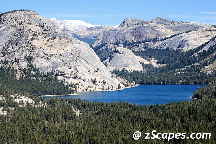
Tenaya Lake
Location
Yosemite Park & Wilderness
Elevation & GPS
8153'
37.83178ºN-119.46007ºW
37.83178ºN-119.46007ºW
Visits & Activity
2007 Mz first image
Interesting Facts & Highlights
Named in 1851 by Lafayette Bunnell of the Mariposa Battalion for the chief of the tribe that had been found living on the shores (Ten-ie-ya). The chief did not feel it was just compensation for the loss of his territory and left his home with a heavy heart. This backdrop is etched in one of Ansel Adams most powerful pictures, with the smooth glacial formations contrasted by the cobalt blue waters. Fishing: Rainbows & Brooks


Tilden Lake
Location
Yosemite Park & Wilderness
Elevation & GPS
8898'
38.1027ºN-119.60404ºW
38.1027ºN-119.60404ºW
Visits & Activity
2005 Gn, Mz camp
Interesting Facts & Highlights
Long and lean, Tilden lake offers a good base camp with the best sites on the southern shore. The western shore trail is close to the waters edge and there is only one good site along the way at a small promontory. Camp here and your sleep will be enhanced by the sound of grazing mule deer. Started as Lake Nina on the 1873 Hoffman map and became Tilden on the McClure map of 1895. Fishing: Rainbows

Lower Twin lake
Location
Yosemite Park & Wilderness
Elevation & GPS
8661'
38.13217ºN-119.68084ºW
38.13217ºN-119.68084ºW
Visits & Activity
2002 Gn, Mz, Gs hike by
1998 Viewed x-Peak 7676
1998 Viewed x-Peak 7676
Interesting Facts & Highlights
Shoreline is tangled with trees on the North side and overran with scree on the opposite shore. Some camp sites near the outlet. Appears to have very minimum traffic. Continue cross country to Peninsula and Otter Lakes. Probably named by the USGS during the 1891-96 Dardanelles map survey. Fishing: Rainbows

Upper Twin lake
Location
Yosemite Park & Wilderness
Elevation & GPS
8911'
38.13672ºN-119.65785ºW
38.13672ºN-119.65785ºW
Visits & Activity
2002 Gn, Mz, Gs camp
Interesting Facts & Highlights
Excellent base camp with access to numerous peaks, day hikes and ridge views. Several outstanding camp sites and a peaceful spot. Most likely named by the USGS during the 1891-96 Dardanelles map survey. Fishing: Rainbows

Vogelsang Lake
Location
Yosemite Park & Wilderness
Elevation & GPS
10341
37.78969ºN-119.3436ºW
37.78969ºN-119.3436ºW
Visits & Activity
2010 Mz, Gn Hi-Sierra camp
Interesting Facts & Highlights
Named by Col. Benson for Alexander Theodore Vogelsang, a president of the Calif Board of Fish and Game commissioners, 1896-1901. However, his brother Charles Adolphus claimed it was named after him in 1907 by another member of the Fish and Game board. The LeConte map of 1900 does show this named as Vogelsang, so that supports the case for Alexander. In either scenario, it has been kept in the family. The name was ratified in 1932 by BGN (United States Board on Geographic Names)
Wilma (Wilmer) Lake
Location
Yosemite Park & Wilderness
Elevation & GPS
7946'
38.07083ºN-119.64173ºW
38.07083ºN-119.64173ºW
Visits & Activity
2006 Gn, Mz, Rl, Tl camp
Interesting Facts & Highlights
Tree fringed shore with a nice camp on the eastern end. Spectacular morning scenes. Named for Wilma Seavey daughter of Clyde Seavey for whom a pass between Kerrick Canyon and Benson Lake is also named. Was mistakenly shown as Wilmer Lake between 1917-1942. Fishing: Rainbows

Bridalveil Falls
Location
Yosemite Park & Wilderness
Elevation & GPS
4521'
37.71673°N-119.64673°W
37.71673°N-119.64673°W
Visits & Activity
2009 Mz first add to website
Interesting Facts & Highlights
The Ahwahneechee tribe believed that Bridalveil Fall was home to a vengeful spirit named Pohono which guarded the entrance to the valley, and that those leaving the valley must not look directly into the waterfall lest they be cursed. They also believed that inhaling the mist of Bridalveil Fall would improve one's chances of marriage. 1855 looks to be the first time the name was suggested by Hutchinson, with 'Falls of Louise' and 'Cascade of the Rainbow' other contenders. With Ostrander Lake as it source, the fall is 620 ft and is a prime example of glacial carving and a resulting hanging valley.

Bridalveil Falls from Old Big Oak Flat Road 2009
Rainbow Effect 2006
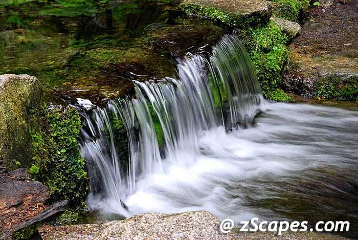
Fern Falls
Location
Yosemite Park & Wilderness
Elevation & GPS
3872'
37.71512°N-119.66516°W
37.71512°N-119.66516°W
Visits & Activity
2009 Mz first image
Interesting Facts & Highlights
May not technically be a fall and is known as Fern Spring, nevertheless, I call this the smallest falls in the park!!! The name origin is unknown as it first appears on the 1883 Wheeler Survey Map. A nice cool spot as you come into the valley.

Horsetail Falls (Firefall)
Location
Yosemite Park & Wilderness
Elevation & GPS
6605'
37.73151°N-119.63166°W
37.73151°N-119.63166°W
Visits & Activity
2009 Mz first image
Interesting Facts & Highlights
A winter only event, usually occurring in mid-February when there is the right mix of temperature to allow a catch basin of water to flow over El Cap, updrafting winds to create misting along the water cascade, and clear skies from the horizon to let the sunset beam into Yosemite Valley. When these are met, this ephemeral event can be as spectacular as the firefalls created in the early days of Yosemite National Park. However, it is elusive!

Nevada Falls
Location
Yosemite Park & Wilderness
Elevation & GPS
5894'
37.72496°N-119.53353°W
37.72496°N-119.53353°W
Visits & Activity
2010 Mz first image
Interesting Facts & Highlights
A 594-foot (181 m) high waterfall on the Merced River in Yosemite National Park, California. It is located below the granite dome, Liberty Cap, at the west end of Little Yosemite Valley. The waterfall is widely recognized by its "bent" shape, in which the water free-falls for roughly the first third of its length to a steep slick-rock slope. This mid-fall impact of the water on the cliff face creates a turbulent, whitewater appearance in the falls and produces a great deal of mist which covers a wide radius, which led to its current name (Nevada is an old Spanish word meaning "snowy"). Additionally, when viewed from the left-hand side, its angular shape is suggestive of the western border of the state of Nevada.
The Indian name was Yo-wy-we, signifying the twist or squirm of the falling water. Lafayette Bunnell suggested the name "Nevada" for the waterfall. He wrote, "The Nevada Fall was so called because it was the nearest to the Sierra Nevada, and because the name was sufficiently indicative of a wintry companion for our spring (Vernal Fall)... The white, foaming water, as it dashed down Yo-wy-we from the snowy mountains, represented to my mind a vast avalanche of snow."
The literal interpretation of the Indian name, Yo-wi-we, presented a problem in then modern day society. 'Squirming or Worm Fall' was just too much sexual innuendo for those times and the name was thus set as Nevada so to not offend anyone. Another tidbit of the times came from Albert Snow, the proprietor of "La Casa Nevada", a hotel operated between the flat between Vernal and Nevada Falls. When discovered by the Mariposa Battalion, the Merced River split off a tiny tributary flowing down a gulch just north of the fall. However, Albert decided this was an aberration of nature and built a diversion to return the water to the main channel so that he "fixed the falls." A good example of the ethos of the time, man is set upon the earth to tame nature. I wonder what would have survived to this day with just a small twist of preservation!

Ribbon Falls
Location
Yosemite Park & Wilderness
Elevation & GPS
6829'
37.73599°N-119.64778°W
37.73599°N-119.64778°W
Visits & Activity
2010 Mz first image
Interesting Facts & Highlights
Flows off a cliff on the west side of El Capitan, and is the largest single-drop waterfall in North America. The fall is fed by melting winter snow; while therefore dry for much of the year, the fall is a spectacular 1,612 feet (491 m) in the spring. In exceptional years, an ice cone develops at its base during the winter months similar to that which usually forms beneath Upper Yosemite Fall. This deposit can reach a depth of 200 feet, versus 322 feet for the greatest depth of the ice cone beneath the Upper Fall. It is the tallest, continuous falls waterfall in the Unites States.
The Indians call this Lung-oo-too-koo-yah, the graceful and slender one. A literal translation is 'Pigeon Basket' and most likely named due to the large population of Pigeons in the area of the creek that feeds the fall. It was Englishized by Mr Hutchings as an English name was desirable.
The Indians call this Lung-oo-too-koo-yah, the graceful and slender one. A literal translation is 'Pigeon Basket' and most likely named due to the large population of Pigeons in the area of the creek that feeds the fall. It was Englishized by Mr Hutchings as an English name was desirable.

Ribbon Falls @ Nite 2010

Royal Arches Cascades (West)
Location
Yosemite Park & Wilderness
Elevation & GPS
4580" (estimate)
37.74989°N-119.57892°W
37.74989°N-119.57892°W
Visits & Activity
2011 Mz first image
Interesting Facts & Highlights
To the north of Ahwahnee Meadows is an interesting series of ridges rising off the vally floor. Right next to and part of the Royal Arches Cascades, this formation gets scant attention as a photo point. My guess is that in summer time the overwhelming panorama found at the meadow overshadows this scene. However, when winter dusts the ridges and granite angles, it is revealed and comes to life.

Tueeulala Falls
Location
Yosemite Park & Wilderness
Elevation & GPS
5372'
37.96692°N-119.78215°W
37.96692°N-119.78215°W
Visits & Activity
2008 Mz, Bf first view
Interesting Facts & Highlights
Falling about 880 feet in two stages, this spectacular fall greets you as you hike the north shore of Hetch Hetchy. John Muir described it as "From the brow of the cliff it leaps, clear and free then disappears in a rage of spattering cascades among the boulders of an earthquake talus." There does not appear to be any reference to what the name means and despite the use by John Muir, it was not officially coined until the 1956 Lake Elanor 15' quad.
Tuolumne Meadows
Location
Yosemite Park & Wilderness
Elevation & GPS
8619'
37.874°N-119.367°W
37.874°N-119.367°W
Visits & Activity
2013 Mz first added to site
Interesting Facts & Highlights
This high country meadow is supported by groundwater that comes from 39" of snow and rain. Water flows from hill-slope aquifers and drains into the Tuolumne River, Budd Creek, Delany Creek and Unicorn Creek. This view is towards the Pacific Crest with Lembert Dome and Mt. Dana.
The Whitney Survey named the meadows on the Hoffman and Gardiner map 1863-67 that is derived from a tribe of Indians that lived in the present day vicinity of Knights Ferry. Living on the banks of the Tuolumne and Stanislaus rivers, they were called 'Taulamne'.
The Whitney Survey named the meadows on the Hoffman and Gardiner map 1863-67 that is derived from a tribe of Indians that lived in the present day vicinity of Knights Ferry. Living on the banks of the Tuolumne and Stanislaus rivers, they were called 'Taulamne'.

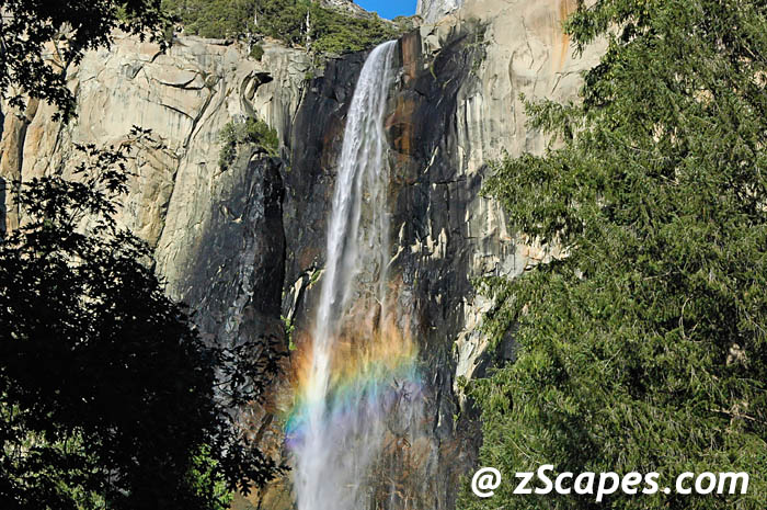
Vernal Falls 2010
Location
Yosemite Park & Wilderness
Elevation & GPS
5064'
37.72787°N-119.54284°W
37.72787°N-119.54284°W
Visits & Activity
2010 Mz first image
Interesting Facts & Highlights
A large waterfall on the Merced River just downstream of Nevada Fall in Yosemite National Park, California. While the official height of the waterfall is 317 feet (97 m), the United States Geographical Survey has measured it at approximately 240 feet (73 m). The feature is accessible via the Mist Trail, which climbs close enough to the fall so that hikers must travel through the fall's mist. It is also clearly visible from Glacier Point. The waterfall runs all year long, although by the end of summer it is substantially reduced in volume and can split into multiple strands, rather than a single curtain of water.
Yan-o-pah (little cloud) was the local name of the fall before rechristened as "Vernal" by Lafayette Bunnell, a member of the Mariposa Brigade in 1851. He states that the cool, vernal spray in contrast at midday with summer heat, reminded him of an April shower. The local name was given because of the mist and spray through which the old trail passed and the circular rainbow that presented itself here, and nowhere else in the mountains.
Yan-o-pah (little cloud) was the local name of the fall before rechristened as "Vernal" by Lafayette Bunnell, a member of the Mariposa Brigade in 1851. He states that the cool, vernal spray in contrast at midday with summer heat, reminded him of an April shower. The local name was given because of the mist and spray through which the old trail passed and the circular rainbow that presented itself here, and nowhere else in the mountains.

Wampa Falls
Location
Yosemite Park & Wilderness
Elevation & GPS
5294'
37.96780°N-119.76548°W
37.96780°N-119.76548°W
Visits & Activity
2008 Mz, Bf first view
Interesting Facts & Highlights
At a drop of 1080 feet, it is similar to Yosemite falls with 3 sections but carries more water volume than it's famed brethren. When this fall is in full production, the crossing bridge is no-mans land and you better be ready to get wet. More importantly, watch your steps as to slip could be fatal. The name is Indian with unknown meaning. First named 'Hetch Hetchy Falls' between 1863-67 on various maps, on 1896 maps it is referred to as 'Macomb Falls' (Lt. Macomb from the Wheeler survey) and finally became Wapama in 1911 on the Yosemite 30' map. This is a difficult picture to catch, as it's best vantage point is from Kolana Rock on the other side.

Yosemite Falls
Location
Emigrant Wilderness
Elevation & GPS
6740'
37°45′18′N-119°35′50′W
37°45′18′N-119°35′50′W
Visits & Activity
2009 Mz first add to site
Interesting Facts & Highlights
The highest measured waterfall in North America is 2420 ft from the top of the upper fall to the base of the lower fall. That qualifies it currently as the 6th highest in the world, however with the recent discovery of Gocta Cataracts in Peru, it appears to have bumped this venerable Yosemite icon to seventh.
The Ahwahneechee people of Yosemite Valley called the waterfall "Cholock" and believed that the plunge pool at its base was inhabited by the spirits of several witches, called the Poloti. An Ahwaneechee folktale describes a woman going to fetch a pail of water from the pool, and drawing it out full of snakes. Later that night, after the woman had trespassed into their territory, the spirits caused the woman's house to be sucked into the pool by a powerful wind, taking the woman and her newborn baby with her.
While most believe it is two tiers, it actually has three sections as detailed below.
• Upper Falls: The 436 metres (1,430 ft) plunge alone is among the twenty highest waterfalls in the world. Trails from the valley floor and down from other park areas outside the valley lead to both the top and base of Upper Yosemite Falls. The upper fall is formed by the swift waters of Yosemite Creek, which, after meandering through Eagle Creek Meadow, hurl themselves over the edge of a hanging valley in a spectacular and deafening show of force.
• Middle Cascades: Between the two obvious main plunges there are a series of five smaller plunges collectively referred to as the Middle Cascades. Taken together these account for a total drop of 205 metres (670 ft), more than twice the height of the Lower Falls. Because of the narrow, constricted shape of the gorge in which these drops occur and the lack of public access, they are rarely noted. Most viewpoints in the valley miss them entirely. Several vantage points for the cascades are found along the Yosemite Falls trail. Several hikers climbing down from the trail towards the cascades have required an expensive helicopter rescue due to steep and slippery terrain and features.
• Lower Falls: The final 97 metres (320 ft) drop adjacent to an accessible viewing area, provides the most-used viewing point for the waterfalls. Yosemite Creek emerges from the base of the Lower Falls and flows into the Merced River nearby. Like many areas of Yosemite the plunge pool at the base of the Lower Falls is surrounded by dangerous jumbles of talus made even more treacherous by the high humidity and resulting slippery surfaces.

Nightfall 2014

Rainbow Fall 2012

Winter Snocone 2013
May our paths & errands meet
Copyright © 1990-2025 zScapes. All rights reserved